A digital twin of the Qutub Shahi Tombs in Hyderabad, India, gives a new lease of life to this important cultural site – identifying areas for restoration and potentially providing future tourists with a novel VR experience, explains Rajesh Dhyani, executive director of R&D, Hexagon Geosystems
In December 2022, an organisation responsible for the preservation of 3,693 ancient monuments and archaeological sites in India reported that 50 of these had gone missing.
As India flourishes into a global technology hub, ensuring that the country’s historical sites are not lost amid rapid modernisation is crucial.
Fortunately, advancements in geospatial technologies are providing a lifeline by creating digital twins of cultural heritage sites. These virtual replicas aid preservation by documenting intricate details, supporting research and education, enhancing tourism through virtual tours and enabling data-driven conservation decisions.
A digital twin for the ancient kings of Hyderabad
One example is the Qutub Shahi Tombs in Hyderabad, India.
These vast monuments are the final resting place of various kings of the Qutub Shahi dynasty, who ruled the region of Hyderabad, eastern India, from the early 1500s to the late 1600s.
The complex was on UNESCO’s “tentative list” to become a World Heritage Site in 2014. To help preserve the site, the local government has been vying for it to become fully recognised ever since. An extensive restoration project has been ongoing since 2013.
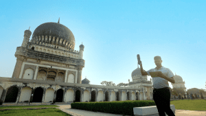
Hyderabad is also home to Hexagon’s largest global R&D facility. So, a team of our engineers recently created a digital twin of the grandest monument on the site – the tomb of Mohammad Quli Qutb Shah.
Built in 1602, this houses the remains of the fifth sultan of the dynasty and founder of Hyderabad after the fall of the ancient city of Golconda.
Capturing every detail
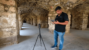
Because of the complexity and size of the monument – spanning a 65m square and rising 42m high – various technologies had to be used to capture it in its entirety, including autonomous flying scanners, handheld laser scanners and tripod-mounted scanners.
A high-precision terrestrial laser scanner with a high range had to be used to capture the tomb’s many intricate details on its four facades: ornamental motifs, small minarets embellished with floral designs and a towering 40m high interior.
A handheld imaging laser scanner was used to obtain comprehensive contextual scans of the tomb’s base and surrounding area. Because of their compact size and lightweight design, these scanners are more practical for getting into tight spaces and for scanning long passages while walking.
Another challenge was the roof. It would have been impossible to scan the roof with a terrestrial or handheld laser scanner without installing extensive, and potentially destructive, scaffolding.
So, a modern flying laser scanner was deployed that features advanced obstacle avoidance – this helped assure the site managers that the project would result in no unnecessary damage and capture details that would otherwise go unseen.
Due to the hot Indian summer sun, scanning sessions could only take place during the cooler times of the day to keep the engineers safe and ensure optimal equipment performance.
Despite all this, it only took engineers from Hexagon three days to scan the whole monument.
Reviving a regal heritage
By the end of the project, a total of 10.7bn data points were taken at millimetre levels of accuracy. Software was used to register and mesh the scans together for refinement, to eliminate extraneous information and generate precise point cloud files.
This dense point cloud data has created a digital twin that now enables preservationists to monitor the site’s condition over time and helps them identify any areas that are at risk of damage or collapse, guiding conservation efforts.
But the benefits of the digital twin don’t stop there. These 3D models were then imported into a cloud platform where they were tailored to enhance viewing them in augmented reality (AR) and virtual reality (VR).
The Government of Telangana in India is currently reviewing the possibility of using these models for AR and VR experiences. These will allow visitors to experience the tomb in a new way, bringing the monument to viewers around the world and helping conservationists plan preservation projects more effectively.
The creation of this digital twin demonstrates how forward-looking innovation and reality technologies can be used to protect our most valued connections to the past as we advance into the future of smart cities.