The University of Florida is bringing together AI and digital twin technologies to build a virtual model of part of Jacksonville in what it called the “future of sustainable urban planning”
Researchers will use the digital twin to test future land use and climate scenarios, as well as to visualise future infrastructure investments.
The information will allow decision-makers to see the potential real-life impacts on the lives of residents and help city planners to adapt to changing climate conditions.
The university said the Jacksonville pilot is just the beginning.
Building Florida’s digital twin
Florida faces aging infrastructure, a changing environment and rapid population growth. A digital twin can help decision-makers make data-driven choices to sustain natural resources, protect community health, ensure economic prosperity and enhance the benefits of future urban planning projects.
Last year, University of Florida (UF) president Ben Sasse allocated $1.75m in strategic funding from the Florida Legislature to build Florida’s digital twin.
The project – led by Dr Christine Angelini, an associate professor and director of the UF Center for Coastal Solutions – aims to harness digital twin and AI technologies to help the state plan for uncertain scenarios.
Using the area of Jacksonville as a pilot location, Florida’s digital twin will reveal details and insights about buildings, roads and wastewater infrastructure.
The university also has a partnership with the AI tech company NVIDIA, and access to big data on Florida’s environmental, health, and infrastructure systems.

Visualising a virtual Jacksonville
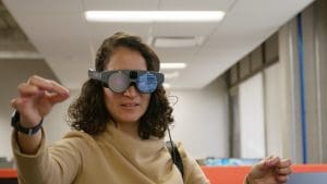
Jacksonville residents and urban planners will be able to wear augmented reality headsets to view rich information about their neighbourhoods.
The research team is now working to enable the headsets to display the potential effects of flooding. This simulation of the real-life physical environment can help city planners develop more cost-effective, efficient and sustainable infrastructure.
One of the researchers at the forefront of this design is Dr Karla Saldaña Ochoa, an assistant professor in UF’s School of Architecture and the director of the Spatial Human-Centered Artificial Intelligence Research & Experimentation Lab.
Dr Saldaña Ochoa helps develop projects that leverage interactions between AI and human intelligence to boost creativity in architectural design.
She wants to have a greater understanding of what is happening to Florida’s environment while making digital twin technology accessible to users from academia, business and government entities, and the community.
“We have access to one of the fastest supercomputers in the United States, which can host all the multi-model data needed to create a digital twin – such as water simulation, a 3D-built environment, and health data,” Dr Saldaña Ochoa said.
“We want to find a way to visualise data from the web interface into Omniverse using the augmented reality goggles: an augmented reality experience.”
Simulating climate change in 3D neighbourhoods
In addition to building the augmented reality component of Florida’s Digital Twin, UF researchers are working to scale the city down into a series of 3D neighbourhoods that will be added to a web-faced interface.
Building an interface of the Jacksonville neighbourhoods that are adapting to climate change was the perfect challenge for Jeff Carney, an associate professor in UF’s School of Architecture and the director of the Florida Institute for Built Environment Resilience.
Carney’s experience researching the role of architecture and city planning in building resilience aligns with the Jacksonville digital twin’s ability to assess flood risks and measure future impacts.
He said: “There’s the impact of storms and floodwater on the buildings and streets today, but what will the impact of the flood look like in six months?
“What’s the impact on the health of the residents two, three or five months after a storm? I think some of those questions will be interesting to explore with the digital twin.”

